Welcome To Hike Los Padres!
User Log In or Sign Up
Use Marker Cluster
Markers: Use Marker Groups
Time used: ms
Routes
    Trails
    OHV Trails
    Forest Roads
    Streams
Wildfire Layers
    Wolf 2002
    Piru 2003
    Day 2006
    Zaca 2007
    Gap 2008
    La Brea 2009
Forest Layers
    Forest Boundary
    Wilderness Areas
    Ranger Districts
    Counties
    Topographic Outlines
    Trailheads
    OHV Trailheads
Helpful Hints
    ↣ Right click the map for location data. ↣ Click a stream for Water Stats.

Buckeye Trail - Los Padres National Forest
Trail Distance 8.61 Miles

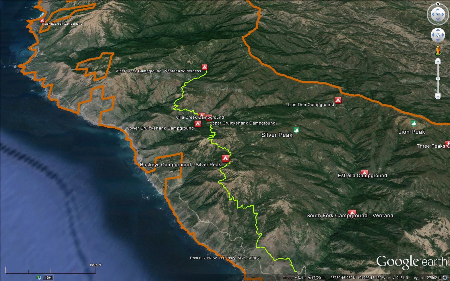
A beautiful trail that has ocean views and travels through oak groves, redwood groves, chaparral. A nice place to camp is at Villa Creek, the camp is set among redwood trees and the creek provides a tranquil sounds of flowing water. The Buckeye Trail is a 8.61 mile long trail in the Silver Peak Wilderness in Monterey County . The trail leads from Highway 1 near Salmon Creek and climbs up and over a few ridges and then completes at South Coast Ridge Road (20S05.6). Please let us know if you have explored this trail recently.

Trail Details

  • Trail #: 5E09
  • Wilderness Area: Silver Peak
  • County: Monterey County
  • Ranger District: Monterey Ranger District
  • Trail-head Latitude: 35.8144
  • Trail-head Longitude: -121.36034
  • Water Sources: Villa Creek is a year round source of tasty water.
  • Trail Condition: Good - Trail is easy to follow and is in good shape
  • Topo Maps:
      Burro MountainVilla Creek
  • `` `` `` `` `` Activities & Features:
    • Backpacking
    • Camping
    • Campfire Rings
    • Creek
    • Day Hiking
    • Panoramic Views
    • Waterfall
    • Wildlife Viewing
    • Wilderness Camping


Trail Stats

  • Total Elevation Gain: + 4560 feet.
  • Total Elevation Loss: - 2686 feet.
  • Overall Average Slope Gain: + 13 %.
  • Overall Average Slope Loss: - 12 %.
  • Kilometers: (km)
  • Meters: (m)
  • Miles: (mi)
  • Feet: (ft)
  • Average Slope: (%)

Trail Camps

  1. Villa Creek Camp (1150 feet)
  2. Alder Creek Camp (2270 feet)
Upload Images Aerial Overview Image Login to Download GPS File
Survey This Trail

Survey Photos:


  • Alan Curtis - 07-10-2017

  • Alan Curtis - 07-10-2017

  • Anonymous Surveyor - 08-04-2017

  • Andrew - 11-18-2017

  • Andrew - 11-18-2017

  • Andrew - 11-18-2017

  • Slokal - 04-16-2021

  • Slokal - 04-16-2021

  • Rob - 04-17-2024

  • Rob - 04-17-2024

  • Rob - 04-17-2024

  • Rob - 04-17-2024

  • Rob - 04-17-2024

Submitted Trail Reports

Buckeye Trail Survey - 10-01-2025 - by David Young
Link: Buckeye Trail
Date: 10-01-2025
Surveyor Name:David Young
Trail description:

Did the sections from Buckeye / Salmon Creek trailhead to Cruickshank Camp. Took us just over three hours plus stops.

The trail was all good, with perhaps the occasional fallen tree and short detour around it


Join Mailing List
×
Get updates on conditions, surveys and more...


Current Weather »


L.P.N.F. Contacts »

  • Forest Headquarters
    Phone: (805) 968-6640
  • Mt. Pinos District
    Phone: (661) 245-3731
  • Ojai Ranger District
    Phone: (805) 646-4348
  • Santa Barbara District
    Phone: (805) 967-3481
  • Santa Lucia District
    Phone: (805) 925-9538
  • Monterey District
    Phone: (831) 385-5434